Haha, OK, very funny, Staten Island…

Now where’s Jimmy Olsen Drive?
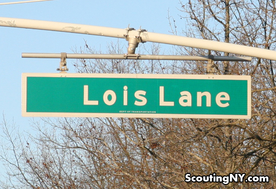
I noticed this as I was driving down South Avenue in Staten Island last Friday. Google seems to think it’s Hughes Avenue – then again, they also insist on mislabeling the Perry White Memorial Highway as the FDR Drive, so what do they know?
-SCOUT
PS – I may have been in some sort of weird nexus of the universe that day – I’ve seen signs to airports, heliports, and marine ports, but this is definitely a first:


Beam me up, Scouty!
Ok, so Star Trek and Superman not the same, I already knew that. But it is a transporter, isn’t it? Never mind. Did you follow the sign?
For the Google Maps error, I would suggest clicking on the lower right corner and use the “report a problem” function.
The Teleport is a project of the Port Authority to bring tech companies/jobs to some vacant land in Staten Island. I think it opened in the early 90s.
That is pretty weird. Google also labels it Hughes Avenue. Whatever complex is down there must have relabeled it Lois Lane. There is also a Lois Place in New Brighton.
Named after the wife of the developer whose building site it is.
There’s one on Long Island, too, in North Sea (Southampton). http://4.bp.blogspot.com/-SOhOpgQGXe4/T1UdX_fcUsI/AAAAAAAAEqQ/zOt4K9kDeo4/s1600/Lois+Lane+Street.jpg
I keep wondering where Margaret Court and Mary Kay Place are.
If there’s one in Southampton, then there are at least two on Long Island, because there is also a Lois Lane in Old Bethpage. Not to mention others in Katonah, Monroe, and Ithaca.
There was (and still may be) a Disc Drive in the Spit Brook area of Nashua, New Hampshire.
Google Maps confirms these names: Reverse Drive, Over Drive, Forward Drive, Mark Lane, Nathan Lane, Night Court, Day Court, Childs Court, Wide Lane, Narrow Lane, Country Lane, Fast Lane, Slow Lane, Glen Close, Quick Road, Boner Drive, Best Road, Scary Road, Slow Road, Odd Road, Near Road, Easy Street
Teleport Drive is a street in there somewhere, where there was a facility which uplinked to communications satellites.
Also off South Ave, is Cable Way, where Time Warner Cable has a facility.
The Teleport is owned by the Port Authority of NY, NJ and PA. At one time the facility was used for secure telecommunications. There was a building on the grounds that looked like a building on the out side but inside was hollow and housed satellites pointing to the sky. You can see using Google maps where the building was. Lois Lane is named for Lois Nicotra. Her husband basically owns that area which is also known as the corporate park of Staten Island.
There is also an Abbey Road in Staten Island that runs parallel to Lennon Court.
Street names are a lot of fun. In Cold Spring, NY, a development centered around Revolution Road leads not to other colonial names but to Yesterday Drive and Norwegian Wood as well as Maggie May. I drove past Down The Lane in Olivebridge, NY, last week and I’ve been on Peyton Place in Middlefield, CT. Carefree, AZ (after whose highway Gordon Lightfoot named a song) features names that reflect the theme including Relaxation Road, Lazy Lane, Nonchalant Avenue and the main downtown intersection of Easy Street and Ho Hum Drive, which itself splits one block later into Ho Road and Hum Road. They’re real – look ’em up!