This past Christmas, my aunt gave me a really neat gift she found in storage. Apparently, my grandmother took a trip to New York sometime in what must have been the 1950’s or early 60’s, and purchased one of those souvenir tablecloths with a cartoon tourist map of New York.
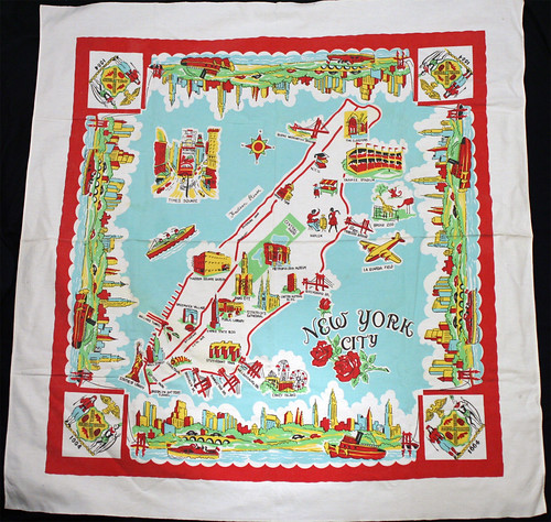
The artwork is great, but the real fun is in seeing how Manhattan was portrayed 40-50 years ago.
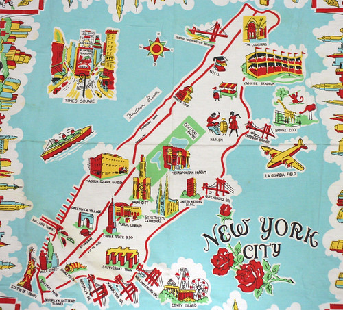
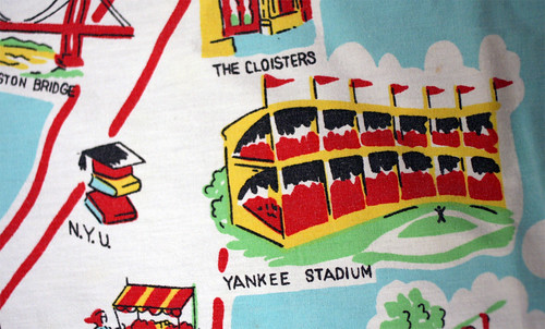
Starting at the north end of Manhattan (apparently smooshed with the Bronx), we find two iconic locales: the George Washington Bridge and the Cloisters.

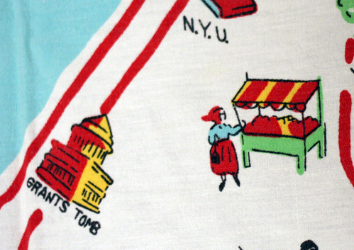
Just south of them is the first oddity: NYU located next to Yankee Stadium?? In fact, NYU maintained a large campus in the Bronx up until 1973, when it was sold to the City University of New York.
There is only one unlabeled drawing on the entire map: this kerchiefed woman at a fruit stand between NYU and Grant’s Tomb. I’m curious if this is supposed to indicate a specific ethnic neighborhood…
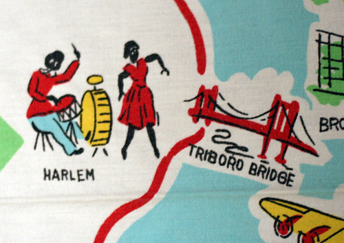
…as they certainly weren’t shy about Harlem (placed on the East Side):
None of the outer boroughs are illustrated, though a few choice tourist attractions are. Just over the Triboro Bridge is the Bronx Zoo…
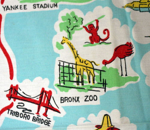
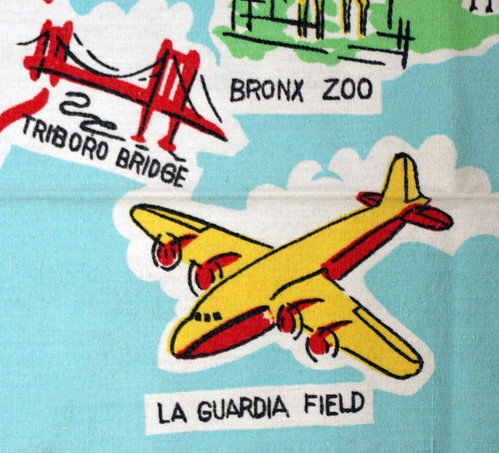
…and below it, “La Guardia Field.”
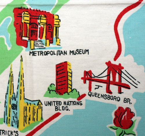
Heading back to Manhattan, we find all the old East Side reliables: the Met, St. Patrick’s, the UN Building, and the Queensboro Bridge…
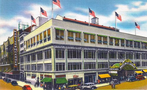
On the west side, you find Radio City Music Hall, and the old Madison Square Garden.
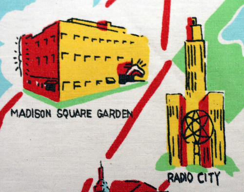
The Madison Square Garden depicted, built in 1925, was closed in 1968.
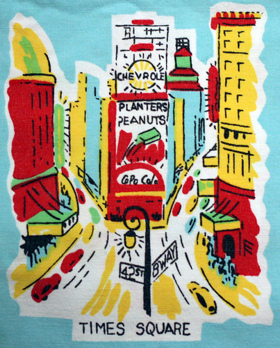
Times Square is represented in a side image of its own. Both “Copo Cola” and “Chevrole” appear to be spelled wrong…Copyright fears?
Heading south, we find a bit of cramming: the Empire State Building on the same level as Greenwich Village/the Washington Square Park arch. Note the artist’s pallet to indicate those Bohemian weirdos.
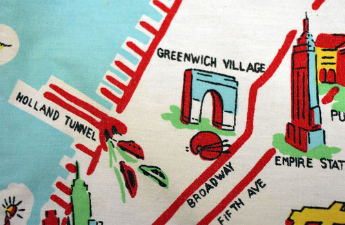
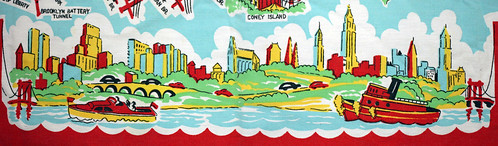
Meanwhile, quite possibly the strangest inclusion on the map is Stuy Town, situated conveniently next to all three lower Manhattan bridges.

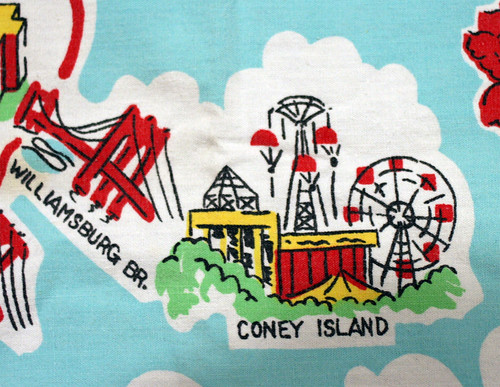
And even better, the Williamsburg Bridge takes you right to Coney Island! Sweet!
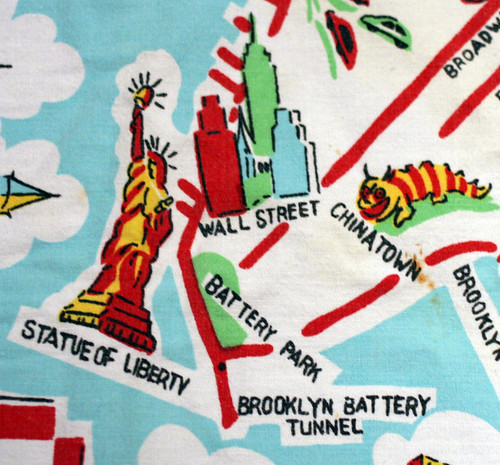
Finally, in the tip of lower Manhattan, we find Chinatown, Wall Street, the Statue of Liberty, Battery Park, and the Brooklyn Battery Tunnel.
I was told this may have come from a visit to the 1939 World’s Fair. However, the inclusion of Stuyvesant Town, which was designed in 1943 and opened in 1947, seems to rule this out. NYU didn’t sell the Bronx campus until 1973, so that narrows the window a bit. Madison Square Garden didn’t move into their new facility until 1968, further closing the gap.
This colorful design borders the map on all sides:
(pan – click for larger sizes)
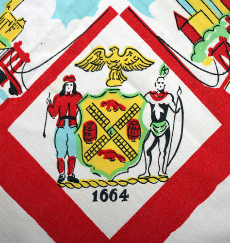
In each corner is the seal of New York:
Finally, I love the New York City logo, with our state flower (apparently), the rose.

I’m planning on having this cleaned and framed. Any others guesses to the date?

-SCOUT
Perhaps it came from a visit to the 1964 New York World’s Fair?
Neat map!
The UN headquarters wasn’t completed until 1952, so that narrows it down a bit more, too.
What a treasure! I love the propeller’d airplane at La Guardia Field.
I think Casey is right, because I found this http://www.thevintagetable.net/catalog/desc/i2045.htm which is a tablecloth similar to the one above that was sold at the 1939 worlds fair
whoops typo on my name 🙂
Pingback: Nabe News: April 28 - Bowery Boogie | A Lower East Side Chronicle
Some insight into the drawing that represents Harlem:
Harlem was the birthplace and epicenter of swing dancing in the 20’s and 30’s. Jazz dance and jazz music were deeply rooted in african-american culture in this area during the 20’s, 30’s, and 40’s. Harlem was also the home of some infamous music & dance venues like the Cotton Club and the Savoy Ballroom.
http://en.wikipedia.org/wiki/Lindy_Hop
I would say that the use of a propeller airplane to symbolize LaGuardia, rather than a jet, places this in the 1950’s rather than the 1960’s. By the 1960’s the use of a propeller airplane would have been considered woefully old-fashioned.
Something unusual about the map is the way it shows Manhattan in the correct north-south orientation rather than pointing due north.
AH! THAT IS BEAUTIFUL!!!! Lucky Scout, and so cool to have fam that knows what you’re into!
Port Authority took over LaGuardia Field in 1947 and changed its name too LaGuardia Airport , although who knows how long it was still commonly referred to as LaGuardia Field.
Fabulous photos, but they exacerbate my nostalgia. I was born in Coney Island and grew up in Inwood (near the base of Fort Tryon Park), neighborhoods that are settings in my novel SWIMMING TOWARD THE OCEAN. Besides the tablecloth I think we had dish towels with something very like the map of New York (above).
I’d go with Casey’s idea of the 1964 World’s Fair. The way that the NY State seal so prominently says “1664” points to a commemoration or anniversary of sorts I think.
What a lovely gift, so appropriate for you! Love your blog.
love EVERYTHING you post
As an obsessive collector of mid-century linens, this is a souvenir “table cloth” from the 50’s. Its most likely – based on the colors and type of block print – a Leacock print. There are a number of souvenir table cloths that are out there from individual states. But the NYC table cloth is fairly rare. As a collector, I can tell you that it is in FANTASTIC condition. If I come across one for sale, I’ll let you know how much collector’s are asking for them. My guess: Its worth about $100 – on the conservative side. Very nice gift!!! I’m envious. Check out this website, if you’re interested in browsing the dorky world of linen collectors: http://www.thevintagetable.net/
Its one I haunt regularly.
I’d date it to about 1951-52 for a few reasons. First, the UN building is shown but looks nothing like what pretty much all tourist memorabilia portrays, probably indicating it was still under construction or brand new.
The inclusion of Stuyvestant Town would have to place it close to its 1947 opening, as it was a very big deal in the early 50s for its role in giving the middle class a decent place to live in what used to be a pretty rough territory.
When I think of the 50s I think of cars and suburbs, and the map shows cars, tunnels, and bridges, but does not depict a single train or mention of the subway! It’s even missing Grand Central and Penn Station, heresy today. The LaGuardia Field mention and the old lamppost on the Times Square graphic also put it toward the early 50s.
The only thing I can’t figure out is why Ebbets Field and the Polo Grounds were not included, though they were so run down by the 1950s and the Yankees such national stars that no one even cared.
I agree with Walter. This is something that would have been sold to tourist in the early or mid fifties. I am bit surprised Ebits field or the Polo grounds were not included.
I hate to be that guy, but words or designs which indicate the source of goods (e.g., “Chevrolet,” “Coca Cola”) are trademarks. Expressive works can be copyrighted. Big difference.
1964 seems like a reasonable guess for the date, but if it were meant to be sold at the fair, wouldn’t it include the giant globe?
The building labeled “Radio City” is the International Building with the statue of Atlas between the wings, across from St. Patrick’s. It opened before WWII, so that doesn’t do anything to narrow the time frame.
I’d date it to about 1951-52 for a few reasons. First, the UN building is shown but looks nothing like what pretty much all tourist memorabilia portrays, probably indicating it was still under construction or brand new.
The inclusion of Stuyvestant Town would have to place it close to its 1947 opening, as it was a very big deal in the early 50s for its role in giving the middle class a decent place to live in what used to be a pretty rough territory.
When I think of the 50s I think of cars and suburbs, and the map shows cars, tunnels, and bridges, but does not depict a single train or mention of the subway! It’s even missing Grand Central and Penn Station, heresy today. The LaGuardia Field mention and the old lamppost on the Times Square graphic also put it toward the early 50s.
The only thing I can’t figure out is why Ebbets Field and the Polo Grounds were not included, though they were so run down by the 1950s and the Yankees such national stars that no one even cared.
I just stumbled upon this and I had to leave a comment saying I have a similar tablecloth with the state of Florida! It has the same vintage design – I’m doing the same thing with getting it framed. It was my grandmother’s from the ’50s or’60s.
This video is amazing! Thank you soooooooooo much for the help. I tried it two weeks ago and i’m still single, but my ex has started calling me again. soooo happy!
I have a strange request! On the hunt for a poster I had as a child (70/80’s). It’s a map of New York with clues round the edge to find the attractions.
Would anyone have an idea where I could buy one of these?
Many thanks for your help in advance!
Best regards,
Emma